
Page 8 - Michigan City, IN US Highway 421 Corridor Plan
P. 8
1.2 Corridor General Description
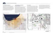
1.2.1 Study Area Boundaries 1.2.2 Composition / Jurisdiction 1.2.3 Location the 421 Corridor Study Area, at the crossroads of US Highway
As depicted in Figure 1.1, 421 Corridor Study Area, the project of General Study Area At the northern edge of Indiana, US Highway 421 runs north- 421 and I-94 is also a gateway and major entrance to the
larger city of Michigan City. The City is a familiar place to people
boundaries include the commercial properties along US The 421 Corridor Study Area is under the jurisdiction of several south in LaPorte County, as depicted in Figure 1.2, Regional who vacation at second homes on Lake Michigan, or visit the
Highway 421, from the Interstate 94 northern right-of-way to public entities. Along County Road (CR) 400 N, Cleveland Context. At the northern end, US 421 starts at S. Franklin Street Lighthouse Place Premium Outlets and Blue Chip Casino; but
Coolspring Avenue; a distance of approximately two and one- Avenue, and Pahs Road is the political boundary between and US Highway 20 in Michigan City. The highway continues for newcomers the US Highway 421 exit and corridor lacks
half miles; and the properties along US Highway 20, from Ohio LaPorte County and the City of Michigan City. The lands from south, passing through the towns of Westville, Wanatah, and landmarks, signage, and a strong identity to captures passersby
Street east to Woodland Avenue; a distance of approximately CR 400 N, Cleveland Avenue, and Pahs Road southward toward La Crosse, but ultimately terminates in Fort Fisher, North and/or businesses to invest
1.75 miles. Noteworthy intersections with the US Highway 421 Interstate 94 are within the jurisdiction of LaPorte County; and Carolina. US Highway 421 is a major north-south link to and
thoroughfare requiring additional focus include CR 400 N/ the lands to the north of these thoroughfares are within the City from Interstate Highways 94 (I-94) and 80/90. At the northern
Keiffer Road, US Highway 20 and Coolspring Avenue. end of US Highway 421, the 421 Corridor Study Area is a major
limits. The US Highway 421 thoroughfare, from US Highway 20
southward; and US Highway 20 thoroughfare are both under node for people traveling between the Chicago metro area and
the jurisdiction of the Indiana Department of Transportation destinations in Michigan. It is 50 miles, about an hour drive,
(INDOT). North of US Highway 20, US Highway 421 becomes east of Chicago and 40 miles west of South Bend. In addition
S. Franklin Street and is under the jurisdiction of the City of
Figure 1.2 Regional Context Michigan City. Figure 1.1 421 Corridor Study Area
20
Ohio St. Ohio St.
W 400 N (Kieffer Rd)
Southwind Dr. Westwind Dr.
S. Franklin St. St. John Rd. Coolspring Ave Coolspring Ave..
421 Larkspur Ln.
94 Meijer Dr.
City of Michigan Barker Rd.
City Urban Areas CR 950 W Cleveland Ave. Cleveland Ave.
Urban Area Boundary
LaPorte County Boundary W 400 N (Kieffer Rd) Coolspring Ave Coolspring Ave..
LaPorte County -
County Boundaries Michigan City Line
Study Corridors Pahs Rd. Study Area Boundary
South Shore Line Parcel Lines
Major Roads Existing Buildings
Woodland Ave.
15 min Driving Distance Trees and Wetlands
30 min Driving Distance Michigan City 20 Water Bodies
45 min Driving Distance La Porte County
0 1000 2000
1-02
1.0 Introduction Adopted: August 16, 2016