
Page 40 - Valparaiso, IN SR 49 Corridor Plan
P. 40
38
3.0 Goals and Strategies
The following provisional goals, strategies, actions and initiatives and beyond are regarded as both prime agricultural and prime Focus Area 1: Residential and Commercial in drafting design guidelines for all development within the SR
for the SR 49 corridor have been developed to advance the desires developable land. In order to consolidate high-quality office / Growth and Development 49 corridor. Deserving particular consideration, with respect
of local citizens and community leaders who have a stake in the professional development close to the SR 49 thoroughfare and to drafting guidelines to regulate development and manage
future of the SR 49 corridor, and want to preserve and manage preserve agricultural lands, county roads and settlement patterns— GOAL 3.1: ACCOMMODATE RESIDENTIAL AND scenic resources are the following county roads within the SR
landscape character of the corridor in the face of potentially the elements that provide the rural landscape character that Porter COMMERCIAL GROWTH AND DEVELOPMENT 49 corridor:
rapid residential and commercial growth and development. The County is known for—an arterial thoroughfare is proposed to run WITHIN THE SR 49 CORRIDOR WHILE PRESERVING • CR E 400 N (SR 49 to CR N 400 E);
goals were also developed in part to advance the objectives of just east of and parallel to SR 49. This alternative thoroughfare LANDSCAPE CHARACTER.
recently drafted, citizen-driven local and regional programs and will provide access to large portions of developable land, and will • CR E 500 N (SR 49 to CR N 450 E);
plans, which call for improvements to transportation and utilities extend southward the Valparaiso Health Center campus proposed Strategy 3.1.1: To increase the degree of control, regulation and • CR E 600 N (SR 49 to U.S. Highway 6);
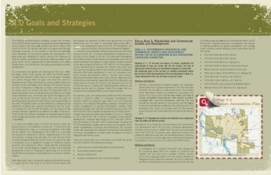
infrastructure, and methods for stimulating sustainable economic at the interchange of SR 49 and CR E 500 N. This thoroughfare, enforcement of land use within the SR 49 corridor, the City of • CR E 650 N (CR N 200 E to N Old Suman Road);
development. named Memorial Drive Extended will intersect Vale Park Road Valparaiso should develop an annexation program to incorporate
and continue southward, where it will provide access to additional • Meska Road (N. Calumet Road to its terminus);
It is understood that growth and development will occur within lands for office park development as well as a proposed multi- the remaining areas of the corridor, as currently delineated within • N Old Suman Road (CR E 600 N to U.S. Highway 6);
the region, within Porter County, and within the SR 49 corridor. family housing development, before it reaches Evans Avenue. the Envision 2030 Comprehensive Plan and illustrated in Map 3.1,
The principal objective of this report is to devise goals, strategies Departing the western alignment of Evans Avenue, Memorial Drive Future Annexation Plan, into the City’s corporate limits. • CR N 300 E (CR E 500 N to CR E 600 N);
and actions through which to guide and direct the nature of Extended becomes elevated, spans the Grand Trunk Railroad, and Initiatives and Actions: • CR N 325 E (CR E 400 N to CR E 500 N);
development so it does not destroy the unique qualities, fabric and slopes down to connect with Porter’s Vale Boulevard and the SR
character of the remaining rural landscape. For several reasons, 2 / LaPorte Avenue. Crossing SR 2 Memorial Drive Extended will 1. Develop a multi-phased annexation program and associated • CR E 700 N (N. Calumet Avenue to Meridian Road);
the City of Valparaiso is regarded as being a free-standing city. directly connect with the Eastport Centre Technology Park and service planning for gradual expansion of the City limits that • Meridian Road (CR E 600 N to U.S. Highway 6);
Its citizens want it to remain that way. The Valparaiso Chain of beyond to the expanding Porter County Regional Airport. prioritizes the annexation of key parcels within the corridor,
Lakes Conservation Area, the Moraine Nature Preserve and Coffee where determined feasible and beneficial, according to the
Creek watershed area, combined with significant regional parks An ambitious plan, the development of Memorial Drive Extended ability of the City to prove that the area meets the State of
such as the Sunset Hill Farm County Park, and vast areas of ensures a coherent pattern of contiguous development that Indiana annexation requirements, with respect to parcel
remaining prime agricultural lands provide a dense green buffer to prevents sprawl and preserves open space and rural landscape contiguity with municipal boundaries; that the City can Map 3.1
County Hwy 700
the north. This green buffer has been effective in halting southerly character. The proposed thoroughfare promotes connectivity and provide the requisite services to said parcels; and the degree County Road 400 Future Annexation Plan
Meridian
movement of sprawl and marginal development from the north. access management to existing transportation corridors while to which the parcels will contribute to the city’s tax base. The Damon Run Coffee Creek
It is through this area that SR 49 passes, and the reason for the providing synergies with adjacent complementary land uses. The annexation plan should be consistent with the City’s growth County Hwy 600
corridor’s northern segment to be referred to as the “rural reach.” SR 49 Corridor Plan promotes the development of livable centers – sequencing plan and coordinated with its capital improvement U V Map 7.5
149
This Corridor Plan provides strategies for strengthening this green multiple use campuses at key interchanges, such as U.S. Highway plan. Andover
500 Pepper Creek Annexation Areas
buffer so agricultural open space can be preserved and managed 6, CR E 500 N and CR E 400 N, to augment transit-oriented Strategy 3.1.2: Regulate the location of residential and commercial U V 49
in perpetuity. development. Improved interchanges at SR 2 and CR E 500 N, land use within the SR 49 corridor. U V 49 Legend Future City Limits Expansion
and the removal of the CR E 600 N interchange increases the County Hwy 150 Beauty Creek Annexation Area
City Limits
It is within the middle reach of the SR 49 corridor where the SR 49 thoroughfare’s safety, level of service and longevity. Multi- Although the City of Valparaiso Comprehensive Plan recommends Campbell Study Area
greatest amount of development is projected. It is also where the modal improvements including recommendations for complete infill development within the city limits, residential development U V U V 2 Valparaiso University
Airport
City of Valparaiso’s image, as a growing metropolitan community streets and expanding the network of recreational trails provides will likely continue to occur within Porter County’s unincorporated 130 Evans County Road 300 325 Wetlands, Ponds, and Lakes
Flood Zone (A)
will be defined. The interchange at CR E 500 N is a principal enhanced connectivity for multiple users throughout the City of areas east of SR 49. To preserve open space and maintain the Morgan Flood Zone (AE)
Streams and Rivers
access point to Valparaiso’s northern neighborhoods to the west Valparaiso and Porter County. integrity of agricultural land uses and overall landscape character, Washington U V 2 U V 2 Railroad
and provides a strong sense of arrival. It is also the site of the it is recommended to prohibit large-scale residential development Valparaiso University
recently developed Valparaiso Health Center, the anchor for what These and several other recommendations for the SR 49 corridor (subdivisions) in excess of ten acres within the SR 49 corridor. £ ¤ 30 Porter County Regional Airport
is envisioned to be a significant complex of healthcare service are outlined within the following focus areas:
providers and professional offices. Along with the development Initiatives and Actions: U V 2
of the Porter County Regional Hospital complex and associated • residential and commercial growth and development; 1. In anticipation of a proposed annexation plan strategy for Abington
development at the U.S. Highway 6 interchange it is envisioned • transportation infrastructure; the remaining lands within the corridor, to preserve and Salt Creek U V ¯
that SR 49 could become a major healthcare corridor for northern • utilities infrastructure; maintain the rural and scenic qualities of Porter County, 49 0 0.35 0.7 1.4 Miles
Indiana. and to encourage agricultural and rural activity, develop an Source: Envision 2030 Valparaiso Comprehensive Plan ADOPTED 06.24.13
Salt Creek
Sievers Creek
• economic development and corridor promotion. intergovernmental agreement between the City of Valparaiso
Within the middle reach, the western portions of the SR 49 corridor and Porter County whereby the County will work with the City
is largely built-out. The lands to the east of County Roads 300
38