
Page 48 - Valparaiso, IN U.S. 30 Corridor Plan
P. 48
Adopted July 25, 2011
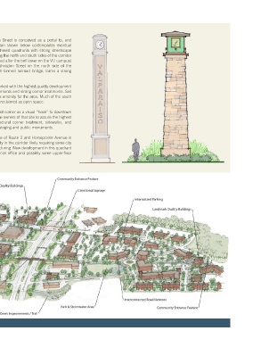
The intersection of Route 2/ Washington Street is conceived as a portal to, and
extension of, downtown. The concept plan shown below contemplates eventual
redevelopment of the northeast and southwest quadrants with strong streetscape
accents and pedestrian improvements tying the north and south sides of the corridor
together. Decorative obelisks (perhaps styled after the bell tower on the VU campus)
are shown bracketing either side of Washington Street on the north side of the
intersection which, together with the arch-formed railroad bridge, forms a strong
entryway to Downtown.
Downtown Vestibule This intersection should be further landmarked with the highest quality development
including buildings with vertical design elements and strong corner treatments. Salt
Creek and its tributaries are opened up as amenity for the area. Much of the south
PLAN SEGMENT side of the corridor east of Route 2 is also reclaimed as open space.
The critical need to landmark the northeast corner as a visual “hook” to downtown
demands that the city work closely with the owners of that site to assure the highest
quality design including a strong architectural corner treatment, sidewalks, and
easements or land dedications for transit-staging and public monuments.
The “triangle” formed by the convergence of Route 2 and Horseprairie Avenue is
the main redevelopment opportunity/priority in the corridor likely requiring some city
facilitation in land assembly and deal structuring. New development in this quadrant
should contain a blend of retail, commercial office and possibly some upper-floor
housing.
18