
Page 46 - Valparaiso, IN U.S. 30 Corridor Plan
P. 46
Adopted July 25, 2011
This area is roughly the ½-mile
segment between the rail road bridges
and Washington Street/Route 2. This is
the most environmentally constrained
section within the corridor with a steep
ridge on the north side of the highway
and wetlands to the south. Land uses
here consist of a hodge-podge of light
industry, retail, and a few aging single-
family homes.
The Trestles Although some redevelopment should
be encouraged on the north side of the
PLAN SEGMENT highway, it will generally be the small-
scale, single-lot variety. A vigorous,
city-assisted redevelopment strategy
is not recommended here. Instead
the strategy should be one of gradual
attrition of existing buildings and uses,
and their replacement with higher
quality commercial buildings over time.
The south side of the highway on
the other hand does warrant a more
proactive strategy on the City’s part
to annex property as opportunities
arise and return it to open space
and recreational use. Deep within
a floodplain, much of this property
probably should have never been
developed in the first place, and
in fact, couldn’t have been without
significant cutting and filling and the
drilling of deep pilings. These filled
in areas could be used for parking or
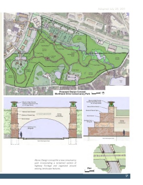
for visitors center for a new creek-side
conservation park that ties into the
main branch of Salt Creek farther west.
The Creek should form the backbone
of a new public greenway system
incorporating hiking and bike trails and
interpretative exhibits. The City should
seek permanent public dedication of
these lands (public trail easements)
incrementally through the annexation
and subdivision process.
Aesthetic improvements to the Norfolk-
Southern trestle are needed and could
include decorative painting to structural
ornamentation such as a medallion Above: Design concept for a new conservancy
with the city logo. park incorporating a reclaimed section of
highway frontage and organized around
existing landscape features.
17