Page 63 - Valparaiso, IN U.S. 30 Corridor Plan
P. 63

Adopted July 25, 2011


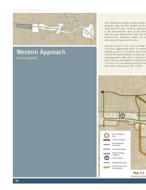
                                                                                         The intersection of Hayes Leonard Road and Highway 30   The City can further restrict what happens in this stretch
                                                                                         generally marks the City’s western urban boundary for the   of the highway by denying or limiting utility extensions
                                                                                         useful life of this plan. Intensive, urban-scale development   or by placing conditions on such extensions that can
                                                                                         is  not  recommended  west  of  the  immediate  4-corner   be  enforced via pre-annexation agreements. Such
                                                                                         area. Any new development should be of a low intensity,   agreements can require the owners’ non-challenge of
                                                                                         predominantly residential nature and sensitive to the   City zoning for a specified period of time following the
                                                                                         environmental features of the area.                 service extension.

                                                                                         Although outside of the city’s municipal boundaries, the   One possible exception to the low intensity rule, could
               Western Approach                                                          City should aggressively assert its extraterritorial planning   be a new master-planned neighborhood or tech park
                                                                                         authority up to and including the intersection of Highway 30
                                                                                                                                             on the western quadrants of the 250-West intersection
                                                                                                                                             where large, buildable sites lend themselves to top
                                                                                         and 250-West (and southward along Route 2).  Extraterritorial
               PLAN SEGMENT                                                              planning powers allow cities to place land use controls on   quality master-planned development projects. Such
                                                                                         lands that may eventually be annexed to the City (so that the   developments may  be considered  under special
                                                                                         City doesn’t end up inheriting poorly planned development.   planned development standards and subject to a
                                                                                         See Indiana Codes section 36-7-4-205).              rigorous site plan review process.


                                                                                                                 Map 3.4, Proposed Pedestrian System


              26
   58   59   60   61   62   63   64   65   66   67   68