
Page 14 - Valparaiso, IN SR 49 Corridor Plan
P. 14
12
12
F F U.S. 6
U.S. 6
G G Calumet Avenue
Calumet Avenue
H H Silhavy Road
Silhavy Road
A A U.S. Highway 30
CR E 600 N
A A U.S. 30 E E CR E 600 N
U.S. 30
I I Bartz Road Connectivity Analysis
Bartz Road
B B SR 2
SR 2
State Routes
J J CR N 325 E U.S. Highways
CR N 325 E
County Roads and Collectors
C C Vale Park Road NOTE: Map is intended for referential use, elements are not to scale. Data used within
Vale Park Road
N N D D CR E 500 N this map is the result of a collaborative effort between Porter County, the City of B B SR 2 (LaPorte Avenue)
Valparaiso, and Kendig Keast Collaborative.
CR E 500 N
related thoroughfares that either intersect or run parallel with SR The recently completed U.S. 30 Corridor Plan defines a strategic Avenue is a four lane minor arterial thoroughfare, with a posted
49. Interchanges within the corridor are located at major east-west vision for improving the function, appearance, and economic speed limit of 35 miles per hour. Between Silhavy Road and SR
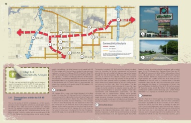
Map 1.2 roadways, including: U.S. Highway 30, SR 2, Vale Park Road (CR potential of a four and one half-mile highway segment that passes 49, LaPorte Avenue consists of two 12-foot wide eastbound travel
Connectivity Analysis E 400 N), Burlington Beach Road (CR E 500 N), CR E 600 N and through the City of Valparaiso. The objective of the corridor lanes; with an 8-foot wide inside- and a 12-foot wide improved
U.S. Highway 6. All of the interchanges within the SR 49 corridor plan was to reconcile the corridor’s multiple and sometimes outside-shoulder. Westbound, beyond SR 49, SR 2 is a four lane
are overpasses, except for the intersection of SR 49 and Burlington competing functions: to move high volumes of through-traffic as major collector, with a posted speed limit of 45 miles per hour.
Beach Road, which is an at-grade signalized intersection; and the well as local traffic; provide access to property; carry important Between SR 49 and Cain Drive, SR 2 consists of two 12-foot wide
This key map was generated using letter keys to represent SR 49 intersection with CR E 600 N, which is stop-controlled. No public infrastructure; connect several of the city’s activity centers, travel lanes in each direction, with a non-mountable center median
specific thoroughfares within the SR 49 study area. Each private drive connections are located along SR 49, between U.S. and serve as the City’s main “face” to the region. The plan and designated turn lanes at the intersection of Porter’s Vale
letter corresponds to a road on the map (above), an Highway 30 and U.S. Highway 6. depicts how the corridor should redevelop in the event of major Boulevard/Eastport Centre Drive. West of SR 49, LaPorte Avenue/
illustrative photo (at top), as well as descriptive text (at changes in market conditions or property ownership, while also SR 2 provides access to both the Porter’s Vale Shopping Center
bottom). A A U.S. Highway 30 making recommendations for proactive, targeted infrastructure and Eastporte Centre business technology park. LaPorte Avenue
improvements and redevelopment opportunities. The plan terminates at U.S. Highway 31, located in South Bend, Indiana.
U.S. Highway 30 is a major rural divided highway. It is the third concludes with an implementation strategy, which presents
longest U.S. route, after U.S. Highway 20 and U.S. Highway 6; with several tools at the City’s disposal, including zoning and special C C Vale Park Road
1.6 Thoroughfares within the SR 49 the western end of the highway terminating at Astoria, Oregon; and design standards; developer incentives; annexation policies; as
Corridor the eastern end terminating in Atlantic City, New Jersey. Despite well as direct public investment in infrastructure, landscaping and Vale Park Road is the eastern gateway to Cumberland Crossing,
long stretches of parallel Interstate Highways, it has managed possible participation in privately led real estate development. and the Calumet Avenue Corridor. Vale Park Road commences
This six-mile section of SR 49 is classified as a limited access, to avoid the decommissioning that has happened to other long at Goodrich Avenue/CR 50 W and terminates at CR N 400 E.
principal arterial thoroughfare and has a posted speed limit of haul routes such as U.S. Route 66. Much of the historic Lincoln B B SR 2 (LaPorte Avenue) Approaching SR 49, Vale Park Road is classified as a two lane
55 miles per hour. Traffic data on SR 49, between U.S. Highway Highway, the first road across America (from New York City to San urban minor arterial, with a posted speed limit of 35 mph. Between
30 and U.S. Highway 6 indicates an annual average daily traffic Francisco), became part of U.S. Highway 30; it is still known by SR 2 (which is named LaPorte Avenue west of SR 49), is the eastern Silhavy Road and SR 49, Vale Park Road consists of two 12-foot
count (AADT) for the year 2011 of 28,326 vehicles per day (vpd). that name in many areas, including within the City of Valparaiso. gateway to the Valparaiso Marketplace retail center, as well as wide travel lanes, one in each direction, with curb and gutter. A
Within the project limits the existing right-of-way width along SR 49 Speed limits range, but are generally 60 miles per hour (97 km/h). downtown Valparaiso. LaPorte Avenue commences at S. Garfield multi-use path is located adjacent to the eastbound lane. The
is 290 feet. During the planning process several smaller, though Avenue and terminates at SR 49. Approaching SR 49, LaPorte intersection of SR 49 and Vale Park Road was reconstructed in