
Page 15 - Valparaiso, IN SR 49 Corridor Plan
P. 15
13
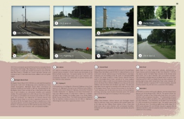
E E CR E 600 N I I Bartz Road
C C Vale Park Road G G N. Calumet Road
D D Burlington Beach Road F F U.S. Highway 6 H H Silhavy Road J J CR N 325 E
2012 from an at-grade signalized intersection to an elevated double E E CR E 600 N G G N. Calumet Road I I Bartz Road
roundabout interchange. The intersection of Vale Park Road and
Silhavy Road is a single lane modern roundabout. East of SR 49, CR E 600 N is classified as a minor collector, and commences at Thoroughfares that run parallel to SR 49 include N. Calumet Road, Bartz Road is a minor north-south collector, commencing at
Vale Park Road is classified as a minor east-west collector and Calumet Avenue, located in Porter County and terminates at the Silhavy Road, Bartz Road, and CR E 325. N. Calumet Road is a minor Evans Avenue and terminating at Vale Park Road/CR E 400 N.
narrows to two 11 foot wide travel lanes, without curb and gutter Porter/LaPorte County Line. The typical section for CR E 600 N north-south arterial, commencing at Franklin Street in downtown The typical section for Bartz Road consists of two 10-foot wide
edges. consists of two 11-foot travel lanes, one in each direction; with Valparaiso and terminating at SR 49, south of Interstates-80/90 travel lanes, one in each direction; with unimproved shoulders.
unimproved shoulders. The intersection of Calumet Avenue and (Indiana Toll Road), located in Porter County. Calumet Avenue, The intersection of Evans Avenue and Bartz Road, as well as, Vale
D D Burlington Beach Road CR E 600 N is stop controlled. south of Burlington Beach Road, consists of an urban roadway Park Avenue/CR E 400 N and Bartz Road are stop controlled. The
section which varies in width to accommodate as few as two-lanes existing right-of-way width along Bartz Road varies between 40-
Burlington Beach Road (CR E 500 N) is an east-west thoroughfare F F U.S. Highway 6 across the Grand Truck Western Railroad to as many as five-lanes and 50-feet; however, it appears that at several locations, adjacent
serving the “north-side” of Valparaiso, and is classified as a minor between Vale Park Road and Bullseye Lake Road. The principal property owners may still own to the centerline of the roadway.
arterial thoroughfare. Burlington Beach Road commences at The Grand Army of the Republic (Memorial) Highway is the official speed limit for this segment of roadway is 35 miles per hour. North
Campbell Street and terminates at SR 49. Approaching SR 49, name of U.S. Highway 6. During the late 1920s and early 1930s, it of Burlington Beach Road, Calumet Avenue takes on the feel of a J J CR N 325 E
Burlington Beach Road consists of two 12-foot wide travel lanes, was also known as the Roosevelt Highway, named after President “rural” roadway, with 12-foot wide travel lanes, defined shoulders
one in each direction; an unimproved shoulder; and roadside Theodore Roosevelt. U.S. Highway 6 runs from Provincetown on and long, sweeping, super-elevated horizontal curves. The posted CR N 325 E is a minor north-south collector, commencing at Evans
ditches. The posted speed limit is 30 miles per hour. This segment Cape Cod, Massachusetts, to Long Beach, California, a distance speed limit for this segment of roadway is 45 miles per hour. Avenue and terminating at CR E 500 N. The typical section for
of roadway is scheduled to be reconstructed within the next two of 3,652 miles, making it the longest route in the United States. CR N 325 E consists of two 10-foot wide travel lanes, one in each
H
years. As mentioned, the intersection of Calumet Avenue and (Porter County Corridor Plan). The 2040 Comprehensive Regional H Silhavy Road direction; with unimproved shoulders. The intersections of Evans
Burlington Beach Road is currently a signalized intersection. To Plan for Northern Indiana envisions the SR 49/U.S. Highway 6 Avenue and CR N 325 E, as well as, CR E 500 N and CR N 325 E
the east of SR 49, Burlington Beach Road is classified as a minor interchange to evolve into a regional economic center. Silhavy Road between LaPorte Avenue and Burlington Beach are stop controlled. The intersection of CR 400 N and CR N 325
east-west collector, commencing at SR 49 and terminating at CR Road is a two lane, major urban collector, with a posted speed limit E is stop controlled for all approach legs. The posted speed limit
N 450 E. The typical section for CR E 500 N consists of two 11-foot of 30 miles per hour. Silhavy Road consists of two 11-foot wide is 40 miles per hour. The existing right-of-way width along CR N
travel lanes, one in each direction; with unimproved shoulders. travel lanes, one in each direction, with unimproved shoulders. 325 E varies between 40- and 50-feet; however, it appears that at
Sidewalks and curb and gutter are located sporadically along the numerous locations, adjacent property owners may still own to the
corridor. centerline of the roadway.