
Page 50 - Valparaiso, IN SR 49 Corridor Plan
P. 50
48
Salt Creek N Campbell StreetN Campbell Street Meridian Road
N CR 350 E
N CR 350 E
N Campbell StreetN CR 350 EN CR 350 EN CR 350 E
N Campbell Street
N Campbell Street
Meridian Road
Meridian Road
Meridian Road
Meridian Road
Meridian Road
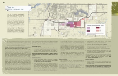
Map 3.7,
Priority Development Sites E Division Road Lincolnway Calumet Avenue CR E 700 N
Lincolnway
CR E 700 N
CR E 700 N
Lincolnway
Lincolnway
Lincolnway
Lincolnway
CR E 700 N
CR E 700 N
CR E 700 N
Calumet Avenue
Calumet Avenue
Calumet Avenue
Calumet Avenue
Calumet Avenue
The City of Valparaiso Redevelopment
E Division Road
E Division Road
E Division Road
E Division Road
E Division Road
Commission should establish partnerships Evans Avenue
with local landowners to ensure that
development is consistent with what is 6
Evans Avenue
Evans Avenue
Evans Avenue
Evans Avenue
Evans Avenue
envisioned and planned for the SR 49
corridor. This map identifies priority sites, the
development or preservation of which will 49
impact the trajectory of this Corridor Plan.
Sites corresponding to Categories A and B
are owned by developers who are interested
in developing their properties according to Bartz Road Priority Development Sites
Bartz Road
Bartz Road
Bartz Road
Bartz Road
Bartz Road
this plan. Category 1 sites represent parcels
that are critical to the development of 30 A 3
B
Memorial Drive Extended and the proposed Coffee Creek 4
CR N 325 E
CR N 325 E
CR N 325 E
CR N 325 E
CR N 325 E
professional office campus. Sites Categories CR N 325 E CR E 400 N (vale Park Road) CR E 500 N CR E 600 N 1 5
3 through 6 represent lands that should be 2 6
preserved in agriculture and forested land. 2 NOTE: Map is intended for referential use, elements are not to scale. Data used within
CR E 500 N
CR E 500 N
CR E 500 N
CR E 500 N
CR E 500 N
CR E 600 N
CR E 600 N
CR E 600 N
CR E 600 N
CR E 600 N
N N N CR 350 E this map is the result of a collaborative effort between Porter County, the City of
Valparaiso, and Kendig Keast Collaborative.
CR E 400 N (Vale Park Road)
CR E 400 N (Vale Park Road)
CR E 400 N (Vale Park Road)
CR E 400 N (Vale Park Road)
CR E 400 N (Vale Park Road)
E CR 400 N (Vale Park Road)
CR N 450 E
N CR 350 E
N CR 350 E
N CR 450 E
N CR 450 E
CR N 450 E
N CR 450 E
N CR 350 E
CR N 450 E
N CR 350 E
N CR 450 E
2. The Valparaiso Redevelopment Commission should consider Silver, and Gold sites on Indiana’s Site Selector Database. Certified in-place concrete “silo” tower. At one time Valparaiso was an • acknowledgement of the three segments of the corridor
the use of tax increment financing (TIF) to purchase property Shovel Ready sites are also included in the Indiana Economic auxiliary (repeater) station on AT&T’s first transcontinental identified (e.g., one sign type for each segment);
and finance infrastructure improvements within the proposed Development Corporation’s (IEDC) marketing materials. microwave route, linking LaPorte, Indiana to the east and • respect for the character of the existing topography;
business parks along Memorial Drive Extended. Chicago Heights, Illinois to the west. Like all of the stations on
Initiatives and Actions: the transcontinental route, Valapraiso was originally equipped • bear a familial resemblance with one another as well as with
Strategy 3.8.3: Support efforts to develop IN OCRA Certified Shovel with KS-5759 delay-lens antennas. These were replaced by the signage program slated for U.S. Highway 30;
Ready sites for new development within the SR 49 corridor. 1. Amend the City of Valparaiso’s Unified Development Ordinance KS-15676 horn-reflector antennas, which increased route
to incorporate the policy recommendations associated with • include seasonal landscaping and berming considerations;
As summarized on Page 28 of this Corridor Plan, the Indiana Office the City’s Envision 2030 Comprehensive Plan, Chapter 4, capacity by allowing the use of more frequencies and two • adhere to the general regulations outlined within the Article
of Community and Rural Affairs (OCRA) administers a Shovel Opportunity, as outlined in Section 2.5.1 of this Corridor Plan. polarizations. 5, Signage, and Article 11, Design Standards, of the City of
Ready designation for developable sites and properties, which 3. This tower is visible from both northbound and southbound Valparaiso’s Unified Development Ordinance.
certifies sites that are ready for economic development. The OCRA Strategy 3.8.4: Develop gateway treatments to significant entrances lanes of SR 49 long before one is actually passing by the
recognizes three tiers of readiness: Shovel Ready, Shovel Ready to Valparaiso from SR 49, including CR E 500 N, Vale Park Road tower’s base. The tower acts as an orienting element and Additional considerations should include setbacks (from buildings,
Silver, and Shovel Ready Gold. As outlined on the OCRA website, and SR 2. provides a sense of arrival and entrance to those traveling thoroughfares); font type and letter sizing (based on setbacks);
the base certification level defines boundaries with a clear title, southbound, toward the City of Valparaiso. illumination; materials; design and articulation (refer to Figure
establishes a price, demonstrates executive level local government Initiatives and Actions: 3.11, Proposed Signage Program, page 49).
support, defines utility capacity, and provides documentation 1. Enhance the Microwave Tower to function as a significant Initiatives and Actions: Initiatives and Actions:
such as Phase I environmental assessment, ALTA, topographical, wayfinding element for the City of Valparaiso (refer to Figure 1. Form a partnership with the property owner whereby the
property layout, and plat maps. Shovel Ready Silver builds upon 3.10, Microwave Tower and Gateway Element). City of Valparaiso can utilize the relay tower as a wayfinding 1. Develop a signage ordinance for the City of Valparaiso’s UDO
those attributes by maintaining documentation that is less than element announcing arrival to the City. that will include all commercial and wayfinding signage within
one year old, has proper zoning, and has infrastructure built to 2. Within the rural reach of the SR 49 corridor, just south of the SR 49 corridor.
the property. Shovel Ready Gold expands beyond Silver by being U.S. Highway 6 and the N. Calumet Road bridge, and west of Strategy 3.8.5: Develop a Comprehensive Signage Program that
less than five miles from a two-lane highway, have seismic data, the SR 49 thoroughfare, stands AT&T Long Lines Microwave promotes the SR 49 Corridor and the City of Valparaiso. Strategy 3.8.6: Promote heritage tourism through the development of
soil borings, are a minimum of 20 acres, and hold a Phase II Relay Tower (for additional information, contact Engineered Criteria for developing a comprehensive signage program should a comprehensive landscape interpretation and wayfinding signage
environmental assessment with no environmental concerns. The Structures, Tel. No. 219 588-6462; Site Name: Valpo North; include the following: program, focused on the region’s unique environmental heritage.
OCRA assists with marketing by featuring Certified Shovel Ready, Site Number: PC01; FCC Registration Number: 1235925). The
tower is a large, 25 foot square, 191-foot tall, type 4D poured-