
Page 51 - Valparaiso, IN SR 49 Corridor Plan
P. 51
49
49
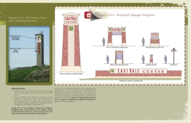
Figure 3.11, Proposed Signage Program
Figure 3.10, Microwave Tower
and Gateway Element
FLOATING PANEL,
MOUNTED
ON TOWER
ARCHITECTURAL valparaiso valparaiso VERTICAL HIGHWAY 49 GATEWAY SIGN NEIGHBORHOOD GATEWAY SIGN
SIGN
LETTERS
DIRECTIONAL WAYFINDING SIGN ADDRESS LOCATOR STREET SIGN
VERTICAL HIGHWAY 49 GATEWAY TOWER
HORIZONTAL HIGHWAY 49 GATEWAY SIGN
Initiatives and Actions: A small-scale commercial development cluster containing retail
1. Work with Indiana Dunes Tourism to establish a list of heritage enterprises such as a small gasoline station, a Panera Bread or
tourism (natural, cultural, scenic) resources within the SR 49 Starbucks-type restaurant, combined with a UPS Store, would
corridor. provide area residents and occupants of adjacent business parks
with modern conveniences that would otherwise require driving in
2. Work with Indiana Dunes Tourism to establish a graphic to Valparaiso to find (refer to Figure 3.12, Neighborhood Commercial,
template and information criteria for interpretive and Plan; and Figure 3.13, Neighborhood Commercial, Perspective on
wayfinding signage that is consistent with and bears familial pages 50 and 51, respectively).
resemblance to signage developed for the Beyond the Beach
Heritage Trail and the Dunes to Kankakee Trail.
Strategy 3.8.7: To serve proposed residential and commercial
development along proposed Memorial Drive Extended, develop
a small neighborhood commercial / retail convenience hub at the
interchange of CO Road 400 and Memorial Drive Extended.