
Page 35 - Valparaiso, IN U.S. 30 Corridor Plan
P. 35
Adopted July 25, 2011
Segmenting The Corridor
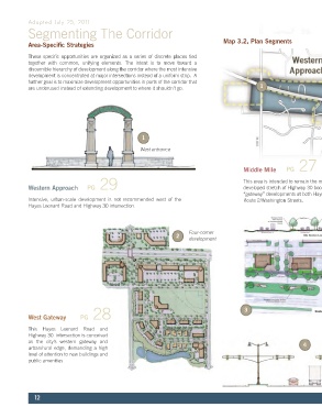
Area-Specific Strategies Map 3.2, Plan Segments
These specific opportunities are organized as a series of discrete places tied
together with common, unifying elements. The intent is to move toward a
discernible hierarchy of development along the corridor where the most intensive
development is concentrated at major intersections instead of a uniform strip. A
further goal is to maximize development opportunities in parts of the corridor that
are underused instead of extending development to where it shouldn’t go. 1
2
3
1
West entrance
PG 27
Middle Mile
PG 29 This area is intended to remain the most intensely
Western Approach developed stretch of Highway 30 bookended by major
“gateway” developments at both Hayes Leonard and
Intensive, urban-scale development is not recommended west of the Route 2/Washington Streets.
Hayes Leonard Road and Highway 30 intersection.
Downtown Vestibule PG 22
Four-corner The intersection of Route 2/ Washington Street
2
development is conceived as a portal to, and extension of,
downtown.
PG 28 3
West Gateway
Streetscape redesign
This Hayes Leonard Road and
Highway 30 intersection is conceived
as the city’s western gateway and
urban/rural edge, demanding a high 4
level of attention to new buildings and Triangle redesign
public amenities 5
12