
Page 40 - Valparaiso, IN U.S. 30 Corridor Plan
P. 40
Adopted July 25, 2011
From a regional transportation standpoint the Highway 30/ SR-49
interchange is Valparaiso’s de facto “front door” and main crossroads.
Its where highest intensity development has occurred outside of
Downtown, and is the hub of the city’s hospitality economy. It is also
the main approach to Valparaiso University from the east. Plans for
the area surrounding the Porter County Municipal Airport will further
position it as an important regional jobs center.
For all of these reasons, this interchange needs to announce –
through quality buildings and highway beautification projects - a
49 Corridor strong sense of arrival into the community. This goes well beyond the
obligatory “welcome to” sign to include heavy doses of ornamental
landscaping, lighting, and architectural design that is a cut above the
PLAN SEGMENT usual corporate prototypes.
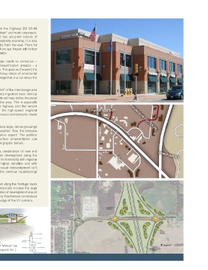
Also because of the generally large “footprint” of the interchange area
the scale of the public improvements is very important here. Vertical
elements such as trees and decorative lights will help define the street
edges and reduce the expansiveness of the area. This is especially
important in the medians separating the highway and the service
roads where some distinction between the high-speed (regional
through-route) versus slow speed (local access) environments needs
to be reinforced.
Plantings will need to be arranged in relatively large, dense groupings
throughout in order to accentuate the separation. Also, the overpass
itself should take on a less purely utilitarian aspect. The addition
of decorative structural elements or surface ornamentation can
transform it into a welcoming archway (see graphic below).
Development in this segment includes a combination of new and
older buildings. It is expected that future development along the
western half of the interchange will occur incrementally with regional
hospitality-type businesses, although in higher densities and with
greater attention to design. (Major, large-scale redevelopment isn’t
anticipated for several years except for the eventual repositioning/
redevelopment of the Wal Mart site.)
Continued infill development is encouraged along the frontage roads
to maximize land use efficiency and to physically enclose the large
surface parking lots. The scale and orientation of development should
also “step down and step out” toward Sturdy Road where cornerpiece
buildings should firmly relate to the outer edge of the VU campus.
New interchange design for Vale Park Road should be
replicated at U.S. 30 (source: American Structurepoint Inc.)
14