
Page 38 - Valparaiso, IN U.S. 30 Corridor Plan
P. 38
Adopted July 25, 2011
PG 24
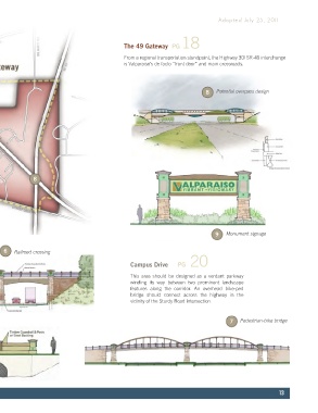
Haymarket The 49 Gateway PG 18
The swath of former industrial land roughly
between Washington and Campbell Streets From a regional transportation standpoint, the Highway 30/ SR-49 interchange
could be repurposed for a combination of is Valparaiso’s de facto “front door” and main crossroads.
small, clean production activities along with
some limited residential uses.
8 Potential overpass design
4 7 9
5
6
8
The Trestles PG 21 9 Monument signage
This ½-mile segment is the most environmentally constrained
section within the corridor with a steep ridge on the north side of 6 Railroad crossing
the highway and wetlands to the south. PG 20
Campus Drive
3 4 6 This area should be designed as a verdant parkway
winding its way between two prominent landscape
features along the corridor. An overhead bike-ped
bridge should connect across the highway in the
vicinity of the Sturdy Road intersection.
7 Pedestrian-bike bridge
5 Stream culvert crossing
13