
Page 195 - Michigan City, IN US Highway 421 Corridor Plan
P. 195
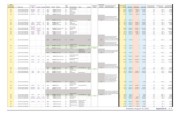
(FID) Environmental
ID # on Parcel No. of Improvement ZONE Undeveloped and Land Use Environmental and Land Use Assessed Value Improvement Value Land Value as % of Land Value Minus
Inventory Map parcels parcel_num Type Year Built Condition ACREAGE Parcel SF Land Use (new) Parcel Description Owner Vacancy Parcels Constraints Constraints Description per SF 2014_Land 2014_Impro 2014_Total to Assessed Value Total Value Improvement Value
Working Well rehab,
230 144 46‐05‐08‐226‐032.000‐009 MEDOFF 1979 AV 1.08 47,044.8 Commercial B2 parking and detention $ 21.97 $ 189,000 $ 844,400 $ 1,033,400 0.8 18% $ (655,400)
231 145 46‐05‐09‐203‐008.000‐073 DWELL 1951 F 0.46 20,037.6 SF Residential R1B residential $ 3.43 $ 19,000 $ 49,800 $ 68,800 0.7 28% $ (30,800)
Working Well rehab,
232 146 46‐05‐08‐226‐031.000‐009 1.43 62,290.8 Commercial B2 parking and detention $ 1.78 $ 100,100 $ 10,700 $ 110,800 0.1 90% $ 89,400
junkyard, behind von
233 147 46‐05‐09‐126‐018.000‐009 5.34 232,610.4 Commercial B2 tobel vacant 5.34 $ 0.20 $ 46,700 $ ‐ $ 46,700 0.0 100% $ 46,700
234 148 46‐05‐09‐202‐006.000‐073 DWELL 1948 P 0.50 21,780.0 SF Residential R1B residential $ 3.18 $ 19,500 $ 49,800 $ 69,300 0.7 28% $ (30,300)
NBHSHOP Community Shopping
235 149 46‐05‐08‐226‐049.000‐009 DISCOUNT 1981, 2014 F, AV 21.39 931,704.8 Commercial B2 Center, TJ Maxx $ 4.43 $ 1,150,700 $ 2,972,600 $ 4,123,300 0.7 28% $ (1,821,900)
236 150 46‐05‐08‐253‐008.000‐009 1.66 72,396.7 Open Space B2 vacant 1.66 $ 1.61 $ 116,300 $ ‐ $ 116,300 0.0 100% $ 116,300
237 151 46‐05‐08‐201‐013.000‐009 0.45 19,645.6 Open Space B2 vacant 0.45 $ 0.55 $ 10,800 $ ‐ $ 10,800 0.0 100% $ 10,800
239 152 46‐05‐09‐203‐007.000‐046 0.46 20,037.6 SF Residential R1B Residential plat vacant 0.46 $ 0.11 $ 2,300 $ ‐ $ 2,300 0.0 100% $ 2,300
240 153 46‐05‐09‐202‐005.000‐073 DWELL 1954 F 0.50 21,780.0 SF Residential R1B residential $ 4.62 $ 19,500 $ 81,100 $ 100,600 0.8 19% $ (61,600)
Existing deciduous trees
241 154 46‐05‐09‐101‐007.000‐009 7.23 314,938.8 Open Space B2 vacant 7.23 throughout parcel. $ 0.03 $ 10,000 $ ‐ $ 10,000 0.0 100% $ 10,000
242 155 46‐05‐09‐203‐006.000‐073 DWELL 1965 P 0.46 20,037.6 SF Residential R1B residential $ 2.75 $ 19,000 $ 36,200 $ 55,200 0.7 34% $ (17,200)
243 156 46‐05‐09‐202‐004.000‐046 0.50 21,780.0 SF Residential R1B Residential plat vacant 0.50 $ 0.11 $ 2,500 $ ‐ $ 2,500 0.0 100% $ 2,500
Hearthside food
244 157 46‐05‐08‐201‐018.000‐009 0.80 34,848.0 Commercial B2 solutions parking lot $ 1.45 $ 19,200 $ 31,200 $ 50,400 0.6 38% $ (12,000)
245 158 46‐05‐08‐201‐015.000‐009 DWELL 1943 P 0.99 42,906.6 Open Space B2 vacant 0.99 $ 0.14 $ 5,900 $ ‐ $ 5,900 0.0 100% $ 5,900
246 159 46‐05‐09‐202‐003.000‐073 DWELL 1945 F 0.50 21,780.0 SF Residential R1B Residence $ 3.79 $ 19,500 $ 63,000 $ 82,500 0.8 24% $ (43,500)
DWELL
248 160 46‐05‐08‐226‐016.000‐009 FASTFOOD 1942, 1984 F, G 1.87 81,413.6 Commercial B2 Starbucks $ 5.56 $ 327,100 $ 125,200 $ 452,300 0.3 72% $ 201,900
Residential Excess
249 161 46‐05‐09‐203‐005.000‐046 0.33 14,374.8 SF Residential R1B Acreage vacant 0.33 $ 0.12 $ 1,700 $ ‐ $ 1,700 0.0 100% $ 1,700
250 162 46‐05‐09‐203‐003.000‐073 DWELL 1953 F 0.34 14,810.4 SF Residential R1B Residence $ 7.18 $ 17,700 $ 88,600 $ 106,300 0.8 17% $ (70,900)
DWELL
251 163 46‐05‐08‐201‐003.000‐009 GENRET 1956, 1999 G, AV 0.42 18,121.0 SF Residential B2 Residence $ 3.60 $ 9,400 $ 55,900 $ 65,300 0.9 14% $ (46,500)
252 164 46‐05‐09‐202‐002.000‐073 DWELL 1962 AV 0.50 21,780.0 SF Residential R1B Residence $ 3.94 $ 19,500 $ 66,300 $ 85,800 0.8 23% $ (46,800)
253 165 46‐05‐09‐101‐014.000‐009 0.48 20,734.6 Commercial B2 Speedway Carwash $ 7.19 $ 119,000 $ 30,100 $ 149,100 0.2 80% $ 88,900
Palustrine system with emergent
vegetation and seasonally flooded
wetland totaling 1.24 acres, swamp
wetland totaling 1.08 acres, and a
second palustrine system with a
aquatic bed unconsolidated bottom
that is a semipermanently flooded
Lake County Trust wetland totaling 1.50 acres. All
Company Trustee three wetlands overlap each other
254 166 46‐05‐09‐101‐009.000‐009 7.20 313,632.0 Open Space B2 Wetland Trust vacant 7.20 totaling 2.25 acres of wetland. $ 0.23 $ 72,000 $ ‐ $ 72,000 0.0 100% $ 72,000
257 167 46‐05‐08‐226‐017.000‐009 0.52 22,651.2 Commercial B2 Arby's parking lot vacant? $ 1.61 $ 36,400 $ ‐ $ 36,400 0.0 100% $ 36,400
258 168 46‐05‐09‐203‐002.000‐046 DWELL 1955 AV 0.33 14,374.8 SF Residential R1B Residence $ 0.21 $ 1,700 $ 1,300 $ 3,000 0.4 57% $ 400
Fannie May Candies
259 169 46‐05‐08‐226‐006.000‐009 0.06 2,439.4 Commercial B2 parking lot $ 1.02 $ 1,300 $ 1,200 $ 2,500 0.5 52% $ 100
260 170 46‐05‐08‐226‐007.000‐009 DWELL 1955 AV 1.15 50,137.6 SF Residential B2 residence $ 2.08 $ 25,800 $ 78,500 $ 104,300 0.8 25% $ (52,700)
SERVICEB
261 171 46‐05‐09‐101‐011.000‐009 CONVMRKT 1965, 1997 G, AV 1.60 69,696.0 Commercial B2 Speedway Gas Station $ 11.20 $ 400,000 $ 380,700 $ 780,700 0.5 51% $ 19,300
262 172 46‐05‐09‐101‐012.000‐009 GENRET 2008 AV 0.97 42,122.5 Commercial B2 Advance Auto Parts $ 20.51 $ 246,600 $ 617,500 $ 864,100 0.7 29% $ (370,900)
El Bracero Restaurant,
MC Sports, Big Lots,
Office Depot, Anytime
263 173 46‐05‐09‐101‐010.000‐009 NBHSHOP 1970 AV 7.54 328,442.4 Commercial B2 Fitness, attached retail $ 6.59 $ 842,600 $ 1,322,900 $ 2,165,500 0.6 39% $ (480,300)
264 174 46‐05‐08‐226‐005.000‐009 GENRET 1960 AV 0.77 33,323.4 Commercial B2 Fannie May Candies $ 3.62 $ 53,700 $ 67,000 $ 120,700 0.6 44% $ (13,300)
265 175 46‐05‐08‐226‐004.000‐009 GENRET 1969 AV 0.34 14,897.5 Commercial B2 Crosstown Liquors $ 6.87 $ 42,700 $ 59,600 $ 102,300 0.6 42% $ (16,900)
266 176 46‐05‐08‐226‐018.000‐009 FASTFOOD 1968 EX 0.47 20,386.1 Commercial B2 Arby's $ 16.67 $ 133,500 $ 206,400 $ 339,900 0.6 39% $ (72,900)
Palustrine system with emergent
vegetation, 0.84 acres of seasonally
flooded wetland, and 0.72 acres of
swamp wetland. Total wetlands
cover 0.88 acres of the existing
267 177 46‐05‐09‐101‐008.000‐009 1.54 67,082.4 Open Space B2 vacant 1.54 parcel. $ 0.23 $ 15,400 $ ‐ $ 15,400 0.0 100% $ 15,400
Palustrine system with emergent
vegetation and seasonally flooded
wetland totaling 1.84 acres, swamp
wetland totaling 0.75 acres, and a
second palustrine system with a
aquatic bed unconsolidated bottom
that is a semipermanently flooded
wetland totaling 1.15 acres. Total
wetland acreage for the parcel is
269 178 46‐05‐09‐101‐006.000‐009 4.20 182,952.0 Open Space B2 vacant 4.20 equal to 1.85 acres. $ 0.05 $ 10,000 $ ‐ $ 10,000 0.0 100% $ 10,000
272 179 46‐05‐09‐203‐004.000‐046 DWELL 1952, 2000 F, AV 0.67 29,185.2 SF Residential R1B Residence $ 2.86 $ 19,800 $ 63,800 $ 83,600 0.8 24% $ (44,000)
A . 6 Appendix A Adopted: August