
Page 21 - Valparaiso, IN U.S. 30 Corridor Plan
P. 21
Adopted July 25, 2011
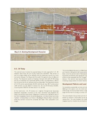
Map 2.3, Existing Development Character
U.S. 30 Today
The surrounding landscape is a virtual transect of the region’s rolling geology of prairie The segment between SR-2 and Hayes Leonard Road is a classic commercial strip
The planned area includes the approximately 4.5 mile segment of U.S. 30 and moraine interspersed with large patches of wetlands and hydric soils. Salt Creek featuring a range of office and retail on deeper lots including the City’s unofficial auto
between State Road 49 and County Road (CR) 250-West. This section is flows under the corridor west of Horseprairie Avenue and a number of interconnected mall. Large commercial signs and overhead utility lines proliferate. West of Hayes
part of a larger stretch of the highway that has historically served as a main tributaries and ditches pose significant challenges to development in the central part Leonard Road, development is significantly thinner with mostly single-family homes
connection between Fort Wayne and the south Chicagoland cities of Joliet and of the corridor especially near the “triangle” formed by U.S. 30, SR-2 and Horseprairie some including some being used for home-based businesses. Beyond 250 West lays
Aurora. The Valparaiso section of highway intersects with both SR-49 linking Avenue. The corridor also touches three different political jurisdictions (correct?) mostly open countryside for seven to ten miles until reaching the Hobart-Merrillville
the City to Chesterton and Interstates 94/90 and 80, and State Road 2 (SR-2) including a large section of Center Township along its southern edge. commercial strip.
that connects the City of LaPorte to I-65 via Valparaiso. The Valparaiso section
of U.S 30 carries approximately 30,000 vehicles per day. SR-2 carries about Development Patterns and Land Use With the exception of a few rare examples, most notably the VU campus, development
1200 vehicles per day where it crosses U.S. 30, and SR-49 about 29,000, along the corridor is generally utilitarian in appearance and isn’t emblematic of the
including about 3500 on the west bound U.S. 30 exit. For analytical purposes the corridor can be broken down into several distinct segments. rest of the City. The city is also not “announced” at either end of the corridor and,
Starting on its eastern end, the short section of highway between the Highway 49 despite a few directional signs, neither are the two main entrances to Downtown at
At the local level, U.S. 30 serves as a regional through-route bypassing interchange and Sturdy Road forms a major entry vestibule for the City consisting of Washington Street and Sturdy Road.
Downtown Valparaiso. It serves as the main connector tying together the larger format retail including a number of hotels and national chain restaurants.
Porter County Municipal Airport, Valparaiso University and a significant part of Typical of mature urban areas, land ownership and parcelization in the corridor is
the City’s hospitality market. Access to Downtown is limited to two main entry The area between Sturdy Road and the Chicago, Fort Wayne, and Eastern railroad very fragmented. There are however a number of good redevelopment and infill
“portals” at Sturdy Road and Route 2 (Washington Street). Major landmarks trestle by contrast is dominated by the university and is mostly rolling, green and opportunities involving vacant or underutilized parcels and older shed-style buildings
along the corridor include the university bell tower (“the campanile”) and campus-like. The area between the trestles is a mix of small-scale industrial and that are nearing the end of their useful lives. (These opportunities are shown in blue
chapel. marginal retail on shallow lots pinched in by ridges and wetlands. on the concept plan map on pages 10-11.)
5