
Page 26 - Valparaiso, IN U.S. 30 Corridor Plan
P. 26
Adopted July 25, 2011
Infrastructure
The corridor is currently a four-lane divided highway along its entire length with eight signalized
intersections. The speed limit is 45-mph and pedestrian access both along and across the highway is
severely limited. Service access roads exist near the most intensely developed portions of the corridor
east of Hayes Leonard Road on the west, and on the extreme east end of the corridor near the 49
interchange. The latter includes an extension of Silhavy Road which is prone to significant backups.
Future traffic projections were not available at the time of this writing.
The combination of railroad tracks, topographical features, disconnected road segments and large-
scale “superblock” development along the corridor, cause its western half to be largely severed
from the main part of the city. As a result, traffic to and from Downtown along the over 7200 foot
segment from Horseprairie to Hayes Leonard Road, is funneled onto just two other secondary roads
(Coolwood Drive and West Street) connecting to Downtown via Joliet Road. Also, the secondary roads
are not designed to carry high amounts of through-traffic.
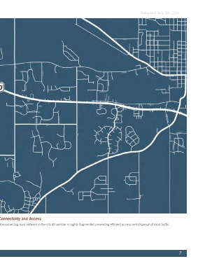
Map 2.5, Connectivity and Access
Above: The interconnecting road network in the US-30 corridor is highly fragmented preventing efficient access and dispersal of local traffic.
7