
Page 76 - Valparaiso, IN U.S. 30 Corridor Plan
P. 76
Adopted July 25, 2011
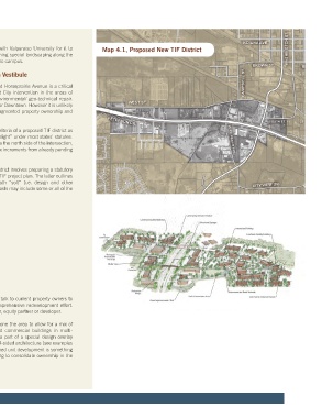
the corridor. The bigger ticket items are likely to be the pedestrian bridges The City should also seek an agreement with Valparaiso University for it to Map 4.1, Proposed New TIF District
on the east (campus) and central segments of the corridor, the obelisk(s) absorb the cost of installing and/or maintaining special landscaping along the
at Washington Street, entry signs at the east and west gateways, and the section of highway that crosses in front of the campus.
structural arch incorporated into the Highway 49 overpass.
Priority Planning Area: Downtown Vestibule
Given its exceedingly high cost, the burying of overhead wires is best done
incrementally in conjunction with major redevelopment projects or major The triangle formed by Route 2, US-30 and Horseprairie Avenue is a critical
road/sewer/water reconstruction projects when the roadway is already redevelopment opportunity requiring direct City intervention in the areas of
“opened up”. The undergounding of utilities should also be coordinated with land assembly, new infrastructure, and environmental/ geo-technical repair.
the installation of high-capacity (4-G+) fiber-optic along the entire length of The entire area is an important tone-setter for Downtown. However it is unlikely
the corridor. to redevelop well on its own because of fragmented property ownership and
serious geo-technical constraints.
Outside of the immediate highway right-of-way, the most expensive capital
improvements will be the various road extensions and realignments shown As stated earlier, the area meets all of the criteria of a proposed TIF district as
throughout the plan. These will have to be developed through a combination far as meeting the technical definition of “blight” under most states’ statutes.
of official mapping/platting, land dedication, special assessments, and Including it in a TIF district that also includes the north side of the intersection,
possibly TIF. Of these, the extension of Campbell Street poses perhaps the may allow the district to passively capture tax increments from already pending
greatest engineering (and cost) challenges. If the costs of this project prove developments in the area.
to be too steep, the City should at least consider installing a bike-ped tunnel
connecting lower Campbell street to the Chicago Dash (TOD) site. The basic process of creating a new TIF district involves preparing a statutory
redevelopment plan and a blight study and TIF project plan. The latter outlines
Necessary environmental infrastructure projects include streambank eligible project costs that may include both “soft” (i.e. design and other
cleanup and restoration along Salt Creek and a handful of site reclamations consultant fees) and “hard” costs. These costs may include some or all of the
east of Route 2/ Washington Street. This work would preferably be prioritized following:
through a comprehensive stormwater management plan, emphasizing
collective detention, for the entire Salt Creek watershed in the vicinity of US- • environmental site assessment
30. Remediation costs may possibly be covered in whole or in part by grants • engineering & design
available through Federal and state departments of natural/environmental • market studies
resources or by the Army Corps of Engineers. • financial feasibility studies
• site acquisition
4. Privately-Led Initiatives • demolition and site prep
• geo-technical stabilization
The phrase “privately-led” belies the fact that such initiatives often take public • sewer and water upgrades
coaxing to get started. Still, the idea is to encourage private business and • new roads and sidewalks
property owners to assume greater stewardship over the highway by taking • stream bank restoration
partial care for it themselves (by directly paying for landscape installation • streetscape
and/or maintenance for instance), or by contributing to a dedicated fund to • stormwater detention
extend the improvements over a larger area. • developer fees
The second of these scenarios is the business improvement district (BID) As a first course of action, the City should talk to current property owners to
model which is already in existence downtown. Although commonly organized gauge their interest in partnering in a comprehensive redevelopment effort.
to maintain publicly-funded landscape improvements, corridor-wide BIDs in Possible owner positions may include: seller, equity partner or developer.
other cities are increasingly involved in funding bigger ticket items such as
stylized entry signs, art installations, transit shelters, decorative lighting and On the regulatory side, the City should rezone the area to allow for a mix of
traffic studies.
medium and small-format, master-planned commercial buildings in multi-
story structures. The area should also be a part of a special design overlay
The City can help encourage more self-help activities by organizing meetings district that requires a minimum of 2-story, 4-sided architecture (see examples
among corridor businesses to facilitate the formation of a working corridor on previous spread). Master planned, planned unit development is something
business association. Later, the City can work with the group on ideas for cost- that the City should actively pursue by trying to consolidate ownership in the
sharing projects and joint promotions. A starter project could be the creation hands of master developer.
of a fund (capitalized by donations from area businesses) to maintain any
city-installed landscaping along the medians.
32