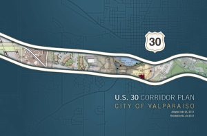
 The U.S. 30 Corridor Plan defines a strategic vision for improving the function, appearance, and economic potential of a 4.5-mile highway segment that passes through the City of Valparaiso. The planning process culminated in an illustrative design and policy document that set forth strategic recommendations for public and private investment activity. It also functioned as marketing collateral, helping to garner $20 million in streetscape and transportation improvements for a local Federal-aid project through INDOT. The City had previously retained KKC to comprehensively redraft its land development regulations into a single Unified Development Ordinance (UDO), and to update its Comprehensive Plan. One of the project’s challenges was to reconcile the corridor’s multiple and sometimes competing functions: to move high volumes of through-traffic as well as local traffic; provide access to property; carry important public infrastructure; connect several of the city’s activity centers, and serve as the City’s main “face” to the region
© 2025 All Rights Reserved